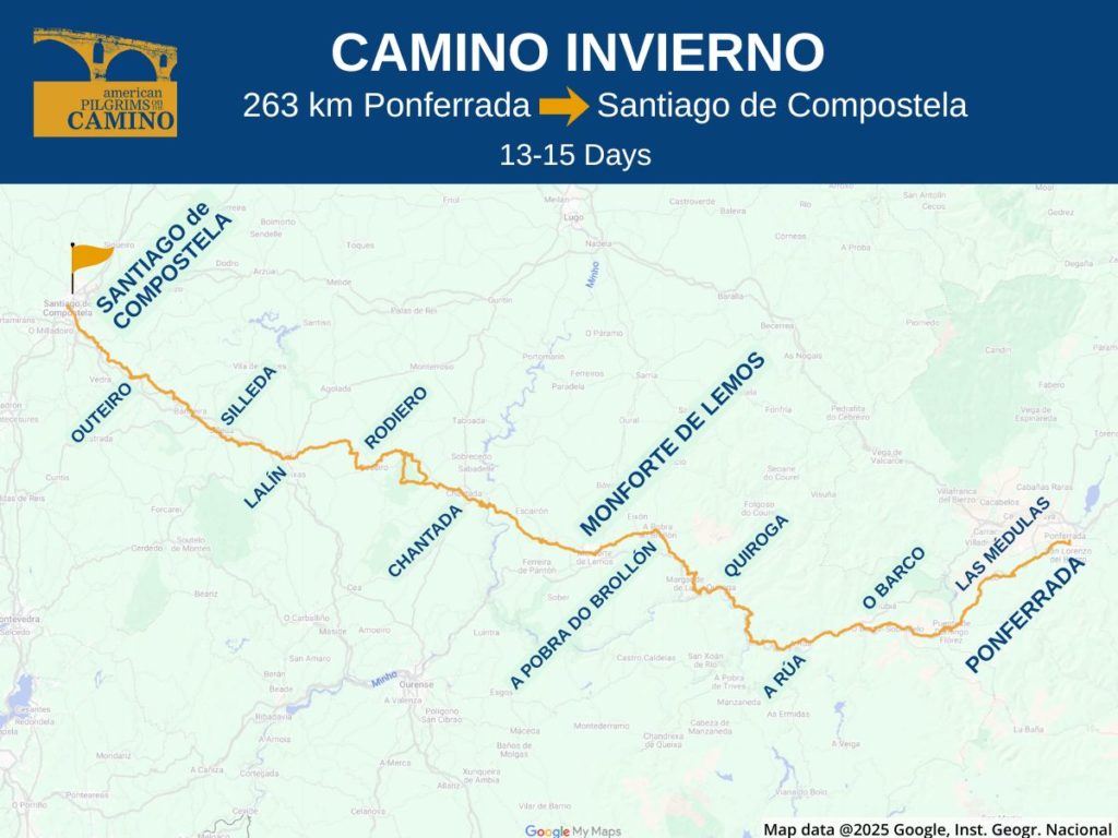
Camino Invierno Route Overview
Are you considering the Camino Invierno? Here’s an overview for this lesser known Camino route. It offers valuable information on where the Invierno begins (and ends), routing options, distances, key towns, the season to go and some tips on how to get there.
About the Camino Invierno
The Camino Invierno (Winter Way) is a 263-kilometer route that begins in Ponferrada in the Castile y León region before entering Galicia and proceeding to Santiago de Compostela. It generally takes 13-15 days. The route was historically used by Roman legions, Napoleonic troops and pilgrims, all of whom were trying to avoid the winter snows that often occur further north in O Cebreiro.
But that doesn’t mean this is a flat route. In fact, while it never reaches the heights the Francés does at the Cruz de Ferro, it’s consistently hilly, sometimes steeply so, and overall, it presents more of a challenge than does the Francés (though perhaps not as much as the Primitivo).
The Invierno is also a wonderfully tranquil rural experience, offering the best of the Galician countryside, with virtually no walking on or near busy through roads. Towns are also more widely spaced, and other than Monforte de Lemos, about halfway, there are no towns as busy as the major stage towns on the Francés.
This route is popular with Spaniards, in particular, and among pilgrims who have already traversed the Francés and who are looking for an alternative way to enter Santiago. It’s also a quieter experience, and over the course of two weeks on the Invierno, you’ll likely see fewer pilgrims than you’ll see on the Francés in two hours. This also means that you’ll need to be a bit more self-sufficient, because you won’t be able to count on fellow pilgrims to point the way if the markers are unclear.
Interesting Things to See and Do
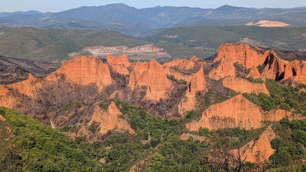
The starting point in Ponferrada offers a Templar castle steeped in Camino lore, and some wonderful, funky museums. One of the main sites on the route is the UNESCO heritage site at Las Médulas. It features an ancient gold mining site, which was once the largest open-pit mine in the Roman Empire. The quarrying has left arresting red rock formations jutting up from the landscape. Las Médulas is a major tourist site in the area, and it’s worth managing your stages so that you can spend some time taking a tour of the mine, experiencing the vista at the Orellán overlook, and visiting the local museum. As for rest days, Monforte de Lemos, about halfway to Santiago, is a thriving town, with some good restaurants and interesting museums.
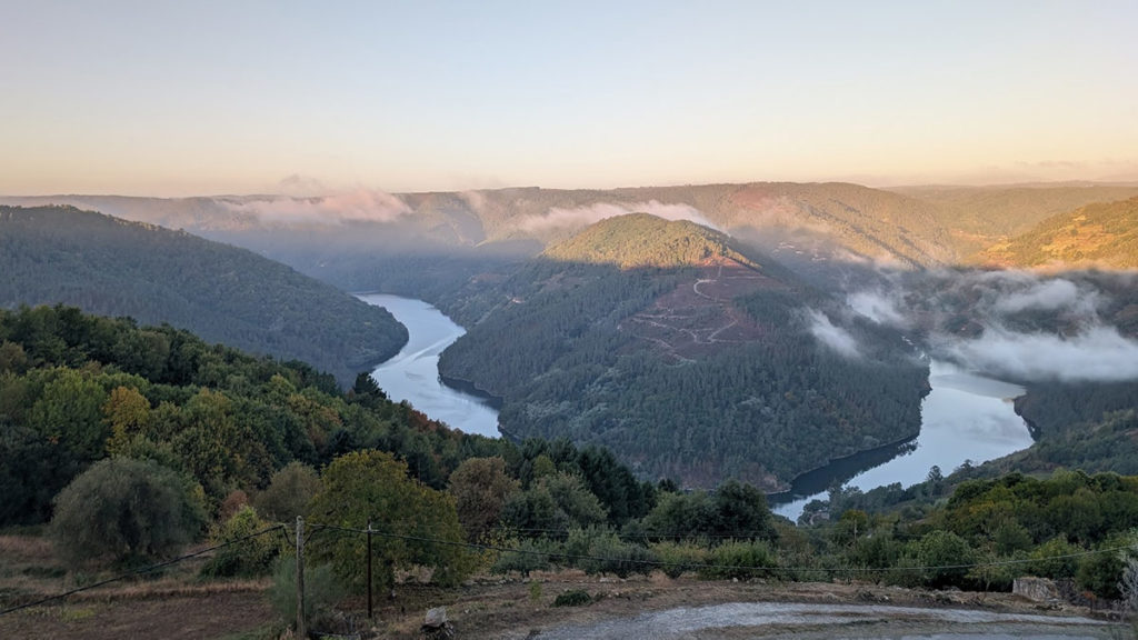
And beyond the history, the Invierno offers a uniformly lovely walk through small towns and tranquil landscapes, usually up in the hills, past terraced vineyards and with wonderful panoramas across the mountains and over the Sil and a succession of river valleys.
Popular Starting Points
Ponferrada is the primary starting point for this route. But some folks start further back on the Francés, switching to the Invierno in Ponferrada. Yet others walk as far as Sarria on the Francés, and then catch a 30-40 minute train or bus ride to Monforte de Lemos, picking up the Invierno route from there.
Monforte de Lemos is just 135 km from Santiago, offering that 100 km sweet spot for those seeking a shorter route, a quieter vibe and a Compostela.
This route also merges with the Via de la Plata/Sanabrés in A Laxe, about 50 kilometers from Santiago.
How to Get onto the Invierno
Madrid is your best international gateway for a variety of flights. Although if you can find a reasonable flight to Santiago de Compostela, that can work too. Regardless of your European arrival airport, plan to spend the better part of one day to get to your starting point.
Renfe is the national train line in Spain. ALSA is one of Spain’s major long-distance bus lines, offering connections to Ponferrada. You can also use Google Maps, Rome2Rio, or aggregators such as Trainline or Omio to help you figure out logistics.
How to Get to Ponferrada
- From Madrid: There are several direct trains a day from Madrid Chamartín to Ponferrada. Alsa also runs buses from downtown Madrid.
- From Santiago: There are several direct trains and Alsa buses each day from Santiago to Ponferrada. And Monbus has one bus a day.
How to Get to Monforte de Lemos
- From Santiago/Madrid: Train from either city via Ourense.
- From Sarria: Multiple trains and buses (on Monbus) to Monforte de Lemos.
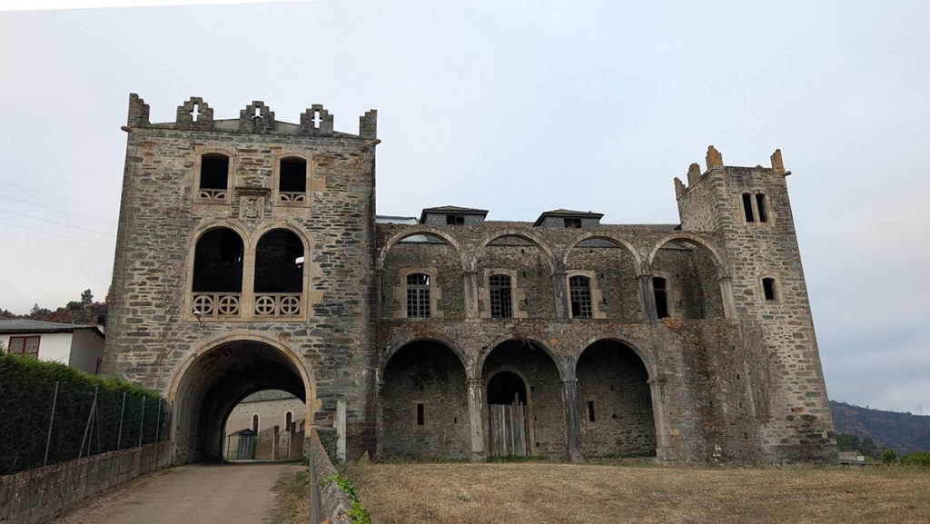
Photo courtesy of Andy Cohn.
Waymarking
The route is well-marked with painted yellow arrows, trail bollards with shell symbols, plaques and signposts, the latter usually with stylized scallop shell symbols. Galicia in particular does an excellent job of marking the Camino and the steady westward direction makes staying on track pretty easy.
That said, the guides outline numerous variants. These include: a major detour to the Las Médulas mine site, riverside variants, alternative routes to albergues and shortcuts. These are unlikely to feature the obvious signage and it’s recommended that you download an app or GPX tracks for offline usage.
Terrain
Expect a lot of walking along pastoral lands, above river valleys, and through chestnut, oak and pine forests. This route is consistently hilly, and if you’ve already walked the Francés, you’ll recognize the terrain as similar to the stages between the Cruz de Ferro and O Cebreiro – but with fewer flat sections and far fewer people.
When to Go
Expect comfortable moderate temperatures between mid-April through mid-June, and then again mid-September to the end of October. It can get hot in the summer. Expect the least amount of rain between June and September.
Accommodation & Services
The Invierno is characterized by fewer lodgings than more popular routes, so it behooves you to plan ahead and be flexible about your lodging type. While you’ll find albergues in the main stage towns, they are rare between them, so you may have to occasionally spend more for a hostal, casa rural, or other private lodging. Thus, unless you stay only in the main stage towns, you can expect to pay more overall than if you were on the Camino Francés, where albergues are plentiful.
Also, because there’s not a steady flow of pilgrims into the lodgings, many places aren’t staffed if no one is expected; it’s generally best to book ahead, or at least let your host know you’re coming. Crowding is rarely an issue, so there’s no need to book far in advance. A day’s notice, or just a few hours, is typically fine.
The guidebooks and apps suggest a few days with rather long stages. But you can break them up with some advance planning and a creative use of the train shuttle after A Rua.
Our Camino albergue and lodging guide will give you information on what types of lodgings are available on the Camino, general pricing and advice on how to book.
Importantly, you should assume there generally will be no services along the way between your daily end points, so be sure to carry provisions for lunch and plenty of water. This is so even if your app or guide mentions a bar along the way, because it may very well be closed when you pass.
Also, other than Las Médulas, this is not a heavily touristed area, and there are far fewer English-speaking pilgrims than on the more popular caminos. So, having some Spanish language skills or comfort in using a translation app will be very useful.
Guidebooks and Maps
The map image at the top of this page comes from this Google Map and it includes the primary GPX tracks. But it’s not designed to be your key resource. For more guidance, we recommend one of the resources below, or load in your own GPX tracks, available from the Spanish Federation.
Some of the major websites and apps offer guidance for the Invierno. You can find them listed on our apps page. If you are keen to do the Las Médulas alternative routing, at this time, the Wise Pilgrim app is the only one with mapping for it.
Thanks to Andy Cohn for helping us put this route overview together. Andy is a chapter coordinator of our Northern California chapter. He did the Invierno from Montforte de Lemos in 2024 and the full route from Ponferrada in 2025.
More Camino Planning Resources
Request your pilgrim credential from us in advance of your Camino.
Be sure to check out our FAQs on planning your Camino and what to expect while on the trail. Or explore other Camino routes.
If you have more questions, be sure to join a local American Pilgrims chapter or join us in our Facebook group.
Rev. 11/20/25